
In June 2012, Rift Energy signed a Production Sharing Contract (“PSC”) covering Block L19, which contains approximately 9,000 KM² (2.2 million acres) in the Lamu Basin. Should Rift Energy make an oil or gas discovery, the strategic location of Block L19 provides a ready market for oil to refineries in Mombasa and natural gas could also be supplied to industrial customers by building a relatively short pipeline.
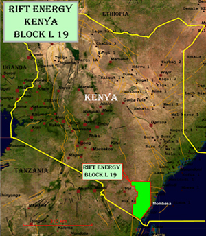
*Note: Highlighted area on map reflects initial acreage (12,00Km², 2.9 million acres) 25% of Block L19 was relinquished during 2014, which occurred in the northernmost section of Block L19.
Technical Data Completed
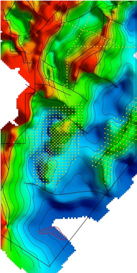
Depth to basement map showing Geochemical Survey data points
- Detect hydrocarbons in the areas of interest.
- Identify the phase of the detected hydrocarbons.
- Differentiate between multiple similar phases if sufficient hydrocarbon differences exist (i.e. multiple oil or gas signatures).
-
Numerous leads and prospects at various depths have been identified, including approximately four drillable prospects and at least 21 leads.
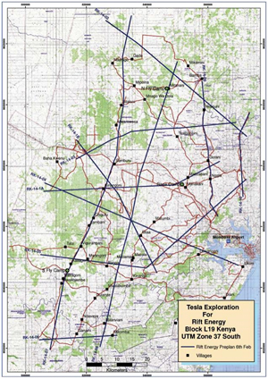
Grid map of 2D Seismic Program
Community Development Projects
During mid-2014, Rift Energy completed ten community projects within Block L19, including water related infrastructure and the construction of six classrooms at various locations within Kilifi and Kwale counties. Rift Energy plans to complete several additional community projects during the upcoming drilling program.

Exploratory Drilling Program
Rift Energy is in the process of evaluating drilling and .png) engineering service tenders for its drilling program, which is expecting to commence later this year.
engineering service tenders for its drilling program, which is expecting to commence later this year.
In addition, Rift Energy is currently in the process of completing the Environmental Impact Assessments ("EIA") that are required for each of our four drilling locations. After completing the EIA and securing additional financing, Rift Energy will initiate its exploratory drilling program on Block L19.


